 |
Bathymetry Survey |
Have you ever wondered what the bottom of
Crater Lake looks like?
New bathymetry survey of Crater Lake started on July 28, 2000. Scientists
from the ![]() USGS and University
of New Hampshire's
USGS and University
of New Hampshire's ![]() Center for Coastal
and Ocean Mapping, in cooperation with the
Center for Coastal
and Ocean Mapping, in cooperation with the ![]() National Park Service,
are conducting a new survey of the lake bottom using the latest high-resolution
multibeam technology. The mapping survey was scheduled to begin on July
24. The survey was delayed because of the fires across the western states;
all commercial helicopters in the area were diverted to fight the fires.
Fortunately, on July 28, the U.S. Army Reserves came to the rescue. A
U.S. Army Reserves Chinnok helicopter from Ft. Lewis, WA used two 37 m
(120 ft) lines to airlift the 8 m (26 ft) research vessel Surf Sureyor
into Crater Lake. The lake surface lies about 305 m (1,000 ft) below the
caldera rim; the lake is accessible only from the air or from Cleetwood
Trail (a 1.6 km or 1 mile-long foot trail).
National Park Service,
are conducting a new survey of the lake bottom using the latest high-resolution
multibeam technology. The mapping survey was scheduled to begin on July
24. The survey was delayed because of the fires across the western states;
all commercial helicopters in the area were diverted to fight the fires.
Fortunately, on July 28, the U.S. Army Reserves came to the rescue. A
U.S. Army Reserves Chinnok helicopter from Ft. Lewis, WA used two 37 m
(120 ft) lines to airlift the 8 m (26 ft) research vessel Surf Sureyor
into Crater Lake. The lake surface lies about 305 m (1,000 ft) below the
caldera rim; the lake is accessible only from the air or from Cleetwood
Trail (a 1.6 km or 1 mile-long foot trail).
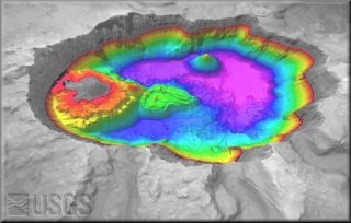
The first surveys to determine the depth of Crater Lake were made in 1886, again in 1938-40, and most recently in 1959. The 1959 survey used echo-sounding technology, measuring the time taken to bounce sound off the lake floor, to collect depth information at over 6,000 locations. The current study uses a high-resolution multibeam mapping system mounted to the bottom of a special boat owned and operated by C&C Technologies of Lafayette, LA. This instrument sends out a fan of sound energy and receives reflected sound through 111 beams of 1.5°, each pointed at a different angle from the vertical. As the boat moves along, more than 30 million depth soundings will be collected. The new system not only provides bathymetric (depth) data, but also records the strength of sound energy that bounces back (called "backscatter"). This information can help scientists identify the materials that make up the lake floor, such as rock, sand, or mud. The new bathymetric map created from this data will be accurate to within 50 cm (1.5 ft) and able to "see" objects larger than 91 cm (3 ft) in diameter!
New data can shed light on the volcanic history hidden by the waters of Crater Lake. Since the first bathymetric maps and dredge haulings were completed dozens of years ago, scientists have sought to determine the nature and timing of vents and landslides that are hidden beneath the water of Crater Lake. Most of what we know today comes from the 1959 bathymetry, dredge samples, submarine video, and samples collected by submarine from the lower caldera walls. Scientists hope the new, detailed, bathymetry study will shed light on certain submerged volcanic landforms and may even lead to the discovery of a new vent. They also hope to find features that can help tell when the lake filled relative to eruptions, identify earthquake-triggered landslide deposits other than the Chaski Slide (the top of which is visible on the south caldera wall), document locations of silica towers that are fossilized hot spring deposits, provide clues to the early eruptive history of Mount Mazama, and identify modern thermal areas (scientists from Oregon State University, National Park Service, and USGS discovered bacterial mats overlying warm springs and dense, warm "pools" of water on the lake floor as recently as 1989).
A similar project from this collaborative effort is the ![]() Lake Tahoe bathymetry. A number of other great Tahoe bathymetric
maps are available at:
Lake Tahoe bathymetry. A number of other great Tahoe bathymetric
maps are available at: ![]() http://walrus.wr.usgs.gov/pacmaps/site.html.
http://walrus.wr.usgs.gov/pacmaps/site.html.