 |
More on DRGs |
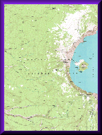
A DRG is produced by scanning a USGS map on a high-resolution scanner at a minimum resolution of 250 dots per inch (dpi). The image is then compressed to reduce the size of the data set. The final result is a packbit-compressed file in the tagged image file format (TIFF), with a file size of 5-15 megabytes. The scanned image includes all map collar information. The four items used for producing a DRG of a 7.5-minute topographic map are:
- USGS topographic map.
- UTM coordinates of the sixteen 2.5-minute grid ticks for georeference and rectification purposes.
- A digital image produced by scanning a USGS map on a high-resolution scanner.
- Software to correct distortion and reference the scanned raster image to ground coordinates.
A DRG may be used as a source or background layer in a geographic information system (GIS) to collect, review, and revise other digital data. A DRG can be combined with a DEM and a DOQ to produce an image with additional visual information for the extraction and revision of base cartographic information.
Extent of Coverage: The standard area of coverage of a DRG is the entire area printed on a USGS standard series topographic map including the map collar, any overedge areas, and insets. DRGs are available at the following scales:
- 7.5-minute map series: Conterminous United States, Hawaii, and limited areas of Alaska at 1:24,000 and 1:25,000 scale.
- 7.5- by 15-minute map series: Covers limited areas of the conterminous United States at 1:25,000 scale.
- Pacific Island map series at 1:20,000, 1:24,000, and 1:25,000 scale.
- Puerto Rico and the Virgin Islands at 1:20,000 scale.
- Culebra, its adjacent islands, and the Island of Vieques at 1:30,000 scale.
- Alaska at 1:63,360 scale.
- 30- by 60-minute map series: Conterminous United States and Hawaii at 1:100,000 scale.
- 1- by 2-degree map series: United States at 1:250,000 scale.