Geologic History
Crater Lake partially fills a type of volcanic depression called a caldera that formed by the collapse of a 3,700 m (12,000 ft) volcano known as Mount Mazama during an enormous eruption approximately 7,700 years ago. The climactic (caldera-forming) eruption of Mount Mazama changed the landscape all around the volcano. Pyroclastic flows of pumice and ash devastated the surrounding area, including all of the river valleys that drained Mount Mazama to as far as 64 km (40 mi) away, and a blanket of pumice and ash fell to the northeast of the volcano at least as far as central Canada. Erosion removed much of this material, feeding rivers that carried it far from its source, ultimately into the Pacific Ocean. Prior to the climactic event, Mount Mazama had a 400,000 year history of activity similar to other Cascade volcanic centers such as Mount Shasta. Since the climactic eruption, there have been several less violent, smaller postcaldera eruptions within the caldera itself.
Mount Mazama was a large composite volcano constructed by episodic growth of many overlapping shield and composite volcanoes, each of which probably was active for a comparatively brief period. Mount Mazama rose to an approximate height of 3,700 m (12,000 ft) above sea level. The erupted magma was mainly andesite. The caldera wall displays the geologic layering of lava flows through time. As the volcanic complex evolved, so did its eruptive style. The eruptions of the last ~70,000 years were highly explosive; the eruptive magma were silica-rich (dacite and rhyodacite). The eruptions of the last ~30,000 years were less explosive; the eruptive magma were low in silica. The only activity in the 30,000 years record, prior to the caldera-forming climactic eruption of ~7,700 years ago, was limited to a small number of preclimactic pyroclastic eruptions and ensuing lava flows of rhyodacite.
Mount Mazama began its climactic eruption about 7,700 years ago, blowing out about 50 km3 (12 mi3) of magma as pyroclastic materials (mostly rhyodacite pumice and fine ash) in at most a few days. The volcanic ash covered parts of the northwestern states to as far as central Canada. Rare particles of Mazama ash have even been found in ancient ice from Greenland. The airfall pumice and ash covered a total surface area of more than 2,600,000 km2 (1,000,000 mi2) at least 1 mm (fraction of an inch) thick, and no less than 13,000 km2 (5,000 mi2) more than 15 cm (6 in) thick. A volume of 42-54 km3 (10-13 mi3) of the mountaintop had disappeared.
Click here to view a map of the distribution of pumice deposits. Image acquired from the 1988 editon of the 1:62,500 scale topographic map entitled "Crater Lake National Park and Vicinity, Oreg."
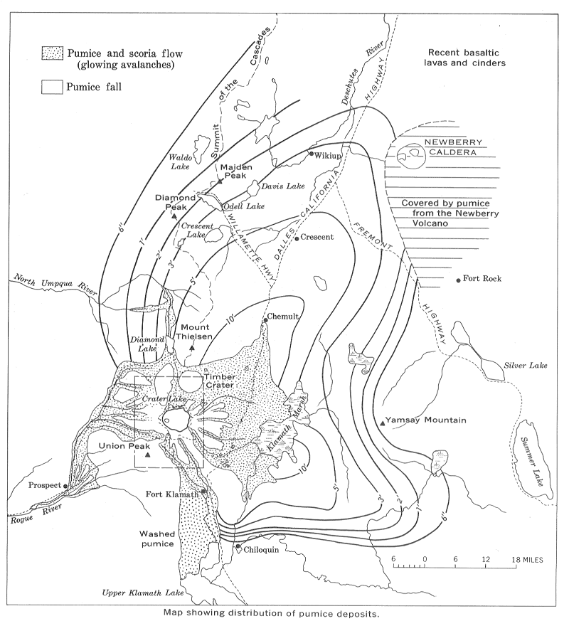
The climactic eruption was fed by magma that had accumulated in a chamber about 5 km (3 mi) below the surface. As the enormous volume of magma (54-63 km3, or 13-15 mi3) was rapidly removed to feed the eruption, the roof of the magma chamber collapsed, forming the bowl-shape depression known as a caldera. The caldera has a diameter of approximately 8 km (5 mi) north to south and 10 km (6 mi) east to west, with an approximate depth of 1,200 m (4,000 ft) from the caldera rim to the lake floor. Pyroclastic flows deposited pumice and ash on all flanks of Mount Mazama and in valleys below.
The landscape after the eruption was a scene of devastation. Geologists have determined that the collapse was a relatively quick event during the eruption, occupying perhaps a few hours or days. All the valleys surrounding the volcano were partially filled with hot pyroclastic flows. The caldera was partly filled with pyroclastic materials and rock debris from its unstable walls. Subsequent to the climactic eruption, all volcanic activity has occurred within the caldera itself. Renewed volcanism built the postcaldera volcanoes of the central platform, Merriam Cone, and Wizard Island.
Following the climactic eruption, it took perhaps 250 years of rain and snow accumulation for the caldera to fill to its present-day lake level. The lake level is maintained by a balance between precipitation and evaporation plus seepage. By that time, the postcaldera volcanoes, nearly all of which are hidden beneath the surface of the lake, had finished their eruptions of andesite lava. Only a small rhyodacite dome was erupted later, about 5,000 years ago.
Studies show that hydrothermal activities are present at the lake floor. Chemical analysis of the lake water and hydrothermal studies indicate that warm water enters the lake from the lake bottom. The water is heated by hot rock beneath the fractured caldera floor. Scientists are not certain whether any magma still remains underground but it is likely that Mount Mazama will erupt again someday.
![]()
The following diagrams show the formation of Crater Lake during the climactic eruption of Mount Mazama. Diagrams are by Charles Bacon, acquired from the 1988 editon of the 1:62,500 scale topographic map entitled "Crater Lake National Park and Vicinity, Oreg."
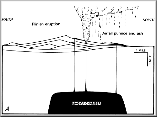
Figure A: Plinian eruption deposits airfall pumice and ash, blown by winds to north and east.
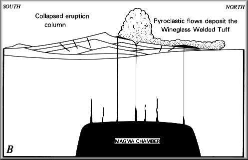
Figure B: Vent enlarges and eruption column collapses; pyroclastic flows deposit the Wineglass Welded Tuff on north and east flanks.
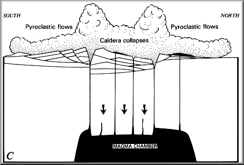
Figure C: Roof of magma chamber collapses, forming caldera as new vents open above fractures; pyroclastic flows deposit pumice and ash on all flanks of Mount Mazama and in valleys below.
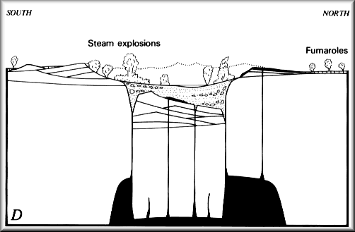
Figure D: Caldera has been partly filled with pumice and ash from the eruption shown in C and with blocks of rock from the caldera walls; weak, dying explosions within the caldera deposit ash on the caldera rim; pyroclastic-flow deposits develop fumaroles and gradually cool.
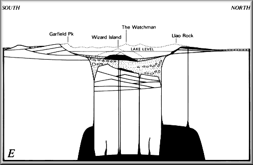
Figure E: Crater Lake today.
![]()
For more information on the geology of Crater Lake, please see: ![]() http://vulcan.wr.usgs.gov/Volcanoes/CraterLake/.
http://vulcan.wr.usgs.gov/Volcanoes/CraterLake/.