 |
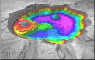
Bathymetry |
Bathymetry survey of Crater Lake started on July 28, 2000. Scientists
from ![]() USGS,
University of New Hampshire's
USGS,
University of New Hampshire's ![]() Center
for Coastal and Ocean Mapping, and
Center
for Coastal and Ocean Mapping, and ![]() National
Park Service used the latest high-resolution multi-beam technology
to conduct a new survey of the lake bottom.
National
Park Service used the latest high-resolution multi-beam technology
to conduct a new survey of the lake bottom.
![]()
Bathymetry Survey
Click on the following to view and learn more about mapping Crater Lake on July 2000:
Introduction to the Bathymetry Survey
Click here for a review of the new and old mapping technology of Crater Lake.
For more information, please visit ![]() USGS
Pacific Seafloor Mapping, Crater Lake.
USGS
Pacific Seafloor Mapping, Crater Lake.
![]()

Data Download
Bathymetry data have been reprojected to the following projection: UTM NAD27 zone 10. The bathymetry data are mosaicked with the 10-m DEM data. The data are provided in a variety of formats for your convenience.
The .dem file is viewable using a USGS program called Dem3D.
2000 Bathymetry Survey
Bathymetry
(2-m resolution, .dem format, 25 MB compressed, 115 MB uncompressed).Bathymetry
(2-m resolution, ArcInfo grid in .e00 format, 43 MB compressed, 273 MB uncompressed).Acoustic Backscatter
(2-m resolution, ArcInfo grid in .e00 format, 50 MB compressed, 286 MB uncompressed).DEM mosaicked with bathymetry
(10-m resolution, .dem format, 28 MB compressed, 103 MB uncompressed).DEM mosaicked with bathymetry
(10-m resolution, .jpg format with world file, 2 MB compressed and uncompressed).Metadata for 2000 Bathymetry Survey
For more information please visit the
http://wrgis.wr.usgs.gov/dds/dds-72/site/data.htm.
1959 Bathymetry Survey
Bathymetry
(30-m resolution, .dem format, 420 KB compressed, 3 MB uncompressed).DEM mosaicked with bathymetry
(30-m resolution, .dem format, 3 MB compressed, 13 MB uncompressed).Metadata not available for 1959 Bathymetry Survey